
These stark images of the Baltic states in winter from London-based photographers Jonathan Lovekin and David Grandorge’s series Ground show how industry and transport shapes the landscapes of Estonia and Lithuania, revealing a very different side of these countries than the one typically presented to outsiders. This essay by Ines Weizman puts their project in the context of other work that poses questions about geographical location and identity.

Infrastructure unplugged
In the years leading up to the millennium it was feared that a computer bug could create global technological chaos on an enormous scale following the breakdown of computers in every sector from banking to medicine to military controls. In February 1999, the International Y2K Cooperation Center (IY2KCC) was created under the auspices of the United Nations with funding from the World Bank to promote increased strategic cooperation and action among governments, peoples and the private sector to minimize the adverse effects of the Millennium Bug on the global society and economy. In Bulgaria, such a regional center was created especially to monitor the countries in central and eastern Europe and in central Asia. Particular precautions were taken to ensure the functioning of nuclear power plants, both in the East and the West, as they depend on external events and interfaces with electrical power systems, telecommunication systems, and other supporting infrastructures.
Preparations were underway across the world: an estimated $400-600 billion was invested to fight a potential error that occurred in digital documentation and data storage systems when a four-digit number was reduced to two digits, due to the fact that when computers were built in the 1960s, years such as 1998 were denoted as 98 to save memory.(1)

Warnings about what would happen if computer programs represented the year 2000 as 1900 or 19100 steered apocalyptic technophobia and end-of-the-world prophecies. Even the United States Deputy Secretary of Defense, John Hamre, in 1999 described the Y2K problem as “the electronic equivalent of the El Niño and [that] there will be nasty surprises around the globe.” (2)
Scientists tried to update these data structures in good time. It was a manageable task for programmers, but precautions were still taken. On the day of the transition, seaports were locked, planes were grounded, ATM machines were closed, surgeries postponed, rollercoasters in fun parks remained stationary, the monitoring systems of nuclear power plants were closely supervised and nuclear missiles were taken off “hair-trigger alert”. To prevent a worst-case scenario, scientists, politicians and policy-makers managed to switch off an enormous global digital infrastructure network. Even if only for a few hours and not completely, the wires and nodes that held global digitized networks together were tied up. The united efforts to tackle the threat from automated machines and robots that were conceived at a time when the year 2000 seemed like a utopian dream, presented a remarkable episode that still offers spatial activists and environmentalists assurance that it is possible to challenge the immanent destruction within pervasive global data systems.

As such, the “power cut” was also a moment of record-taking. The International Atomic Energy Agency was overseeing 425 nuclear power plants that were in operation in 31 countries worldwide advising on intensive diagnostic and corrective activities that had to be conducted to “find and fix” their Y2K software and equipment problems, supplemented by contingency plans. The bug suddenly managed to create a universal enemy – an imagination that embraced the vulnerability of the entire world, connecting the ecological and the digital, bytes and atmosphere. The episode corresponded to a previous moment, just 28 years earlier, in which a photograph of the Earth – catalogue number AS17-148-22727 – was captured by NASA’s Apollo 17 crew on December 7, 1972. Laura Kurgan writes about the public impression of the first image of Blue Marble:
“The 1972 photograph, no doubt because it both offered the viewer the whole Earth and seemed to remove any viewer from the picture, became perhaps even more of an icon, not only of totality and unity but likewise singularity and freestanding vulnerability.”(3)
In its own way, it combined the digital image with analog Earth.
In 2016, 438 electric nuclear generators were in operation worldwide and 67 new nuclear plants were under construction in fifteen countries. A network of potential disaster hubs spans the globe; they exist among us, though usually out of sight. The enormous power they are able to generate feeds a huge energy network that sets in motion both a material and immaterial infrastructure. Data flows entangle humans and nature into an informational complex. Nature has already lost its “wildness” and “inviolacy”, it has become man-made, while human decision making is being replaced by faster, more reliable and efficient semi and fully autonomous robots and machines that manage and negotiate data, which in turn, shapes contemporary global infrastructures. Information flows of a financial, legal or military nature congeal into a wide array of strange “spatial products”, extraterritorial “zones” and building nodes. Keller Easterling describes this “infrastructure space” as itself a medium of information: “The information resides in invisible, powerful activities that determine how objects and content are organized and circulated. Infrastructure space, with the power and currency of software, is an operating system for shaping the city.”(4) Today, every bit of landscape has to be suspected of being in some ways under the control of a machine. Connected through the ground, the air, through wires, radiation, fluids or dust particles, infrastructural systems, technologies and natural world intersect in an aggressive and destructive way.
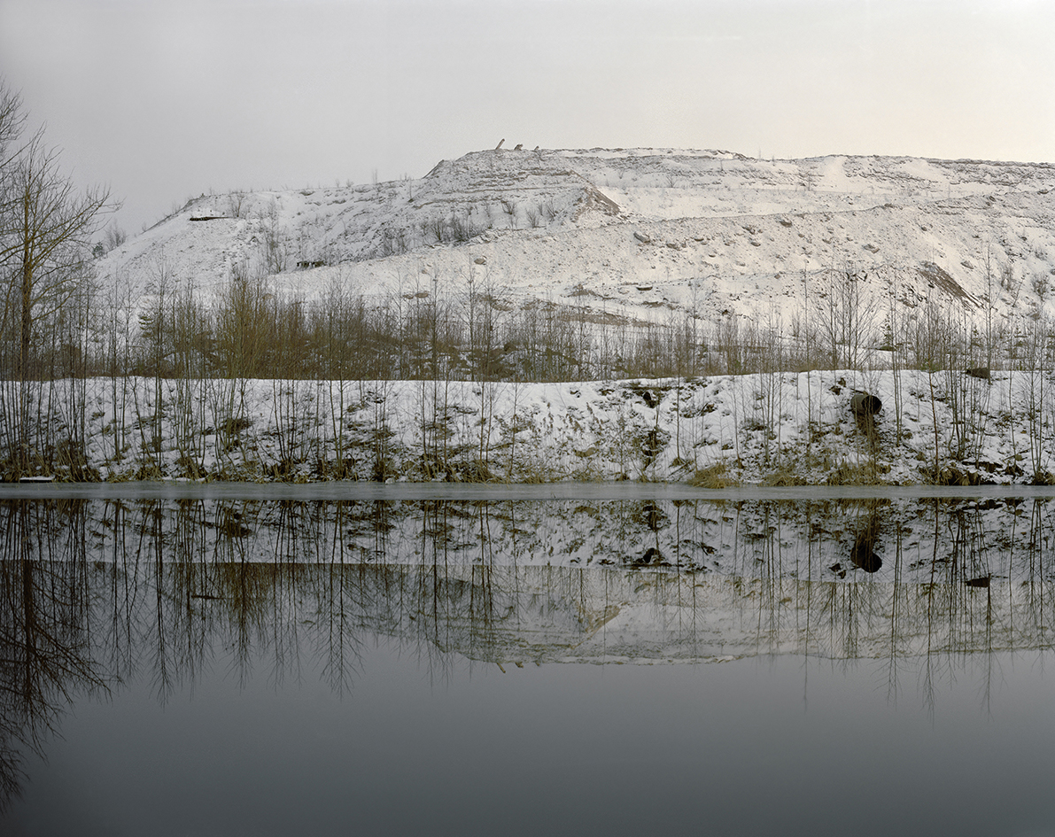
The London-based photographers David Grandorge and Jonathan Lovekin set out for Lithuania, Estonia and Latvia to research a region – the Baltics – that since the political upheavals of 1989 has undergone far-reaching transformations during which the region gained renewed significance and new cultural allies. Their photographs document a critical understanding of material processes and fossils, derived from a complex dynamic infrastructure of industries, transport logics, urban waste and demand.

The Baltics are historically shaped by a multiplicity of actors and a plurality of spaces that do not necessarily overlap. Researching and identifying their boundaries and meanings requires exploratory methods and alertness to almost imperceptible symptoms. To be clear, these photographers are not the type of people who mean to “capture” a site. In addition, they are not necessarily thrilled by current photographic tropes, such as images of decay from the former socialist countries of Eastern Europe. They don’t read their objects and landscapes as a return to a world that “in the West has already long gone and here is still fully intact” – a connotation for which color photography can at points be misunderstood. Buildings decorated with propaganda paraphernalia, housing estates with prefabricated panels typical of 1970s and 1980s planning in socialist countries, factories, industrial sites and sublime scenes of enormous man-made mountains where excavated materials are piled up– for Grandorge and Lovekin these do not represent the sites of past infrastructures unplugged from power. They are not taking us back into the future of the past, into a nostalgic – that is, wrongly remembered – utopia. Rather, the cables and wires of the objects and infrastructures in their photographs are alive – still hot, still connected to the power circle, and still longing to be reinstated. Their gloomy vampirism only seems to hide the autism of animated matter.

The photographers ask for universal measures to be taken for understanding these manufactured landscapes by means of revealing the very objects within the infrastructure, as the nodes and hubs in which data and energy flows are produced, exchanged and distributed. As such, the photographic series in which they are investigated and documented represent pieces of an enormous puzzle, a map – or an atlas of sorts that offers the type of architecture that can represent the complex regional formation of the Baltics, in which political, linguistic, ethnic, religious, economic, and social boundaries overlap.(5) This map also seeks to open up the Baltic countries beyond the touristic representation of the region through healthy forests, lakes and freshly renovated historical city centers such as those in Vilnius with its colorful baroque buildings and Catholic churches.

In Paris, in the late 1920s, Fernand Braudel was researching his doctoral thesis at the Sorbonne. The topic – Philip II, Spain, and the Mediterranean in the Sixteenth Century – was planned to cover the king’s lifetime between 1527 and 1598 and his reign over an empire that included territories on every continent known to Europeans.(6)

For his study, Braudel visited archives in Spain, Italy and Yugoslavia, where he recorded thousands of archived documents on film rolls (he is often described as the inventor of microfilm) which he, along with his wife, and a team of assistants, later studied and filed until the late 1940s. In 1935, he accepted an offer to teach at the newly established university in Sao Paolo, Brazil, a chance to break away from French academic life. He later claimed that it was in Brazil that he became intelligent.(7)

His work was interrupted while teaching in Brazil, and in 1940 he was drafted to fight in the French army. His service ended in Prisoner of War camps in Germany – first in Mainz and after 1942 in Lübeck – from which he was only released in 1945. Apparently in the POW camp in Mainz he was able to do some research in a library, and in Lübeck even managed to write the first draft of his manuscript about the Mediterranean into exercise books while imprisoned with twenty prisoners in a small room. Based on those notes and having memorized his previous research, he was able to immediately continue his writing after the war. However, in all likelihood, his experience of the war and the distance from his homeland of France caused him to see the Mediterranean from different geographical angles and shift the focus of his research, renaming his work The Mediterranean and the Mediterranean World in the Age of Philip II.

When the book was published in 1949, it was no longer about the narrow national context of Spain and the tight temporal constraints of the seventy-year lifespan of the ruler; rather, it offered a panoramic reflection on the Mediterranean Sea, which Braudel understood as a “vast, complex expanse” that included the surrounding mountains, plains and deserts, and on the impact that geology has on cultures connected by the sea. To grasp the connections and repeating patterns between culture and cultural possessions, Braudel argues, the study of world history must be total: “One can say, for example, that a civilization (or a culture) is the sum total of its cultural assets, that its geographical area is its cultural domain, that its history is cultural history, and that what one civilization transmits to another is a cultural legacy or a case of cultural borrowing whether material or intellectual.”(8) To capture this totality as a history he introduced a structure of three timespans: the longue durées, which described slow and imperceptible changes to climate and environment; the shorter durations of empires, civilizations and social groupings, which the former was compared to; and a third category of timespans, that of people, events and political upheavals that pierced and disturbed the others. In fact, he considers the actors and revolutionaries belonging to that last histoire événementielle as too weak and insignificant – or perhaps simply too short – to be relevant in his totalizing vision of history.

At the center of his theory are objects, statistics, and all sorts of details about the everyday that provide evidence of a certain persistence of conservative habits under the surface of the kind of transformations that conventionally attract the historian’s attention. Although a Marxist, he is less interested in the historical materialism that illustrates class struggle; rather, he hopes to undo the rules and inner logic that seem to keep the world system stable. His universal reading of history does not need biographies and monographs to reveal the larger configurations that hold world history together. Certainly, he does not reject the research on people, but he does reject the attempts of historians to focus on characters in depth without seeing the larger continuities in time and their relations with other disciplines.

In his recent book The Baltic: A History, Michael North embarked on a history of the entire Baltic Sea region from the ninth century to the present day. In the opening pages, he notes that Baltic studies lacked an interdisciplinary approach of the sort that Fernand Braudel had pioneered for the Mediterranean. Certainly, the interest in writing the cultural history of regions such as the Baltic or the Balkans also has to be understood as a historiographical project that aims to take an emancipatory stand against the logic of the expansion of the European Union – or that of the Russian Federation, which threatens to revert to some of the power politics and borders of the Soviet Union. (Vladimir Putin’s dive in the Black Sea in August 2015 – a well-mediatized mini-submarine expedition to an ancient Russian shipwreck – marked out very clearly national interests and claims of ownership over that part of the territory.)
[vimeo 155527267 w=640 h=360]
However, North rejects the idea of a history of the Baltic à la Braudel “because it would presuppose an all-powerful nature that ineluctably determined the physical setting in which the peoples around the Baltic Sea lived their lives. But there is no such thing as a single Baltic. Rather there are many Baltics, which, from Adam of Bremen to Björn Engholm and the Baltic Sea strategy of the EU, have been constantly reinvented and reconstituted by trade and cultures and by the merchants and artists who have embodied these historical trends.”(9)

Michael North captures the history of the Baltic in a fascinating study of the various political regimes and ideologies that formed today’s Latvia, Estonia and Lithuania, in relation to the history of Poland and the former Soviet Union – of which they were part at different periods – and today in relation to the Russian Federation. With similar intentions, albeit using very different aesthetic means and methods, Grandorge and Lovekin embark on a reading of the cultural history of the Baltic – not as a regional survey, or as specific characterization of national differences, but on the contrary, as a study of objects and spatial settings that have become the nodal points of an infrastructural network that crosses both temporal and geographical borders. While rarely pointing their camera towards the waters of the Baltic Sea itself, they detect what North called “an all-powerful nature that ineluctably determines the physical setting in which the peoples around the Baltic Sea lived their lives.”

The photographic series that Grandorge and Lovekin titled Ground, in its very crafting and composition, refers to schools such as the one started by the photographers Bernd and Hilla Becher in the 1970 and 1980s, and to seventeenth-century Dutch landscape painters. Both saw their motives analytically, documenting architectures and landscapes from ground level or from an only slightly heightened perspective at eye-level. But Ground is also a cartographic project of sorts, one which points out transport arteries such as train tracks, roads, pipelines, high voltage transmission lines, or the cable conduits and freight corridors that make the Baltic a trans-national and trans-border entity.

The series of images of Ignalina, the location of the only nuclear power plant in Lithuania – shut down in 2009 with the support of the European Bank for Reconstruction and Development (EBRD) as part of the EU Baltic Strategy Program – shows an industrial site that still seems able to operate. The switches and diagrams showing the flow chart of the energy production process of the two reactors and the danger zones in the building, and the emergency procedure notices, would appear only to require only a dusting off before going back into production. The danger of switching on a new nuclear power station in Visaginas, was reverted by a public referendum in 2009, which effectively endorsed a nuclear phase-out in Lithuania and the Baltic region. Following the nuclear disaster at Chernobyl, which had similarities in reactor design to the Ignalina nuclear power plant, a robust anti-nuclear national mobilization stopped the construction of a third reactor and eventually influenced the process of decommission.(10)
In addition, the images of the railway tracks document a new pan-Baltic project that is largely supported by the European Union. The new Rail Baltica project, planned to start in 2020, will expand the existing railway system to link the Baltic States with Poland and Finland, and eventually, Central Europe. This railway project will help to shift heavy freight transport in the region from motorways to rail and will expand the logistics of cargo services.

But the expansion of the new railway network also includes some technical problems that might have political implications. Because of the different development of railway networks in nineteenth-century Europe and in the Russian Empire, and later in the former Soviet Union, including the Caucasian and Central Asian republics, trains run on different gauges from the Finnish border all the way to Mongolia and China. The hard-earned political independence of the Baltic states from the centralized state apparatus of the Soviet Union after 1989 and 1990 demanded gestures to be made in all areas of culture, right down to the width of the train tracks. Apparently, one of the first political gestures made by Estonia following the restoration of its independence from the Soviet Union, was to redefine its track gauge to match Finland’s, in order to be different from the Russian gauge. Although the Rail Baltica project, according to the EU regulations on unified standards, envisions the introduction of a standard gauge for all member states, for financial reasons the current plans might only allow for an upgrade (rather than a replacement) of the existing Russian gauge rail between Tallinn and Kaunas. However, in October 2015 the completion of the first phase of the Rail Baltica project was celebrated in Kaunas, inaugurating the 125km extension of the standard-gauge track from the former break-of-gauge at Šeštokai to Marijampolė and Kaunas in Lithuania.

The uppermost layer of the Anthropocene
The photographers manage to document the uppermost, thinnest layer of the Anthropocene; snow-flakes, clouds, dust, mineral deposits and slowly trickling water that gently cover much deeper man-made geological strata seen in scars on the surface of the Earth. Open-pit mines and quarries, water channels scratched into the terrain, disused industrial water basins and sites of chemical leaks present open wounds, human-inflicted injuries on nature that destroy, modify and mutate matter – organic or inorganic – into a poisoned and poisonous new artificial land. In some images, the fragments of infrastructure begin to blend into each other. The gray of the ground has become part of the same spectrum of gray as the birches, the concrete façade of a cement factory, the dusty machines and the background of gray mist and dusts that constitute the very pixels and pigments of the photographic prints. The colors represented in this sick and contaminated ground appear to be of the very same chemical constellation as the chemical color pigments of and on the photographic paper. The dramatic color spectrum of argent-stained birches, cinereous concrete walls, amaranthine brickworks and viridian-green and chrome-blue industrial waters are imprinted on the paper, making it tactile and almost possible to smell for the viewer. This form of mediation between the territory, its scars, its drains; and the waste sites, side-effects and residues of production, and the almost direct transportation of its substances into a new, though reflective production for yet another infrastructural project – involving cultural understanding and collaboration between sites – is to be taken both metaphorically and literally.

We are looking at matter, at the end of a chain of processes – waste material, remnants of still active industrial processes that have turned matter into energy, data and dust.
Chemical leaks, residues of industrial processes, colored earth turned over and carved out are the remains of social, economic and chemical events and processes that are now past, but whose afterlife represents a burden and duty of care for this new Baltic Sea region. An accident looms in these photographs, interrupting the flow of information and data, and creating a knot in infrastructural systems like the next Unix Millennium Bug, predicted for 2038.

1. Evan, William M.; Manion, Mark 2002. Minding the Machines: Preventing Technological Disasters. Upper Saddle River: Prentice Hall PTR, p 77.
2.CNN 1997. Reference in: Fava, Sergio 2013. Environmental Apocalypse in Science and Art: Designing Nightmares. London: Routledge, p 61.
3. Kurgan, Laura 2014. Close Up at a Distance: Mapping Technology, and Politics. New York: Zone Books, p 10.
4. Easterling, Keller 2014. Extrastatecraft: The Power of Infrastructure Space. New York: Verso, p 13.
5. See Editor’s note below.
6. Eric R. Dursteler and Fernand Braudel (1902-1985), In: Philip Daileader, Philip Whalen (eds) 2010. French Historians 1900-2000: New Historical Writing in Twentieth-Century France. London: Wiley-Blackwell, p 65.
7. Braudel, Fernand 2001 (1998). Memory and the Mediterranen. New York: Vintage Books.
8. Braudel, Fernand 1995 (1993). A History of Civilizations. London: Penguin Books, p 8.
9. North, Michael 2015. 8. The Baltic: A History. Cambridge MA: Harvard University Press, p 2.
10. Hindmarsh, Richard A.; Priestley, Rebecca (eds.) 2016. The Fukushima Effect: A New Geopolitical Terrain. London: Routledge, lk 134.
Ines Weizman (PhD) is professor of architecture theory, director of the Bauhaus-Institute of History and Theory of Architecture and Planning and director of the Centre for Documentary Architecture at the Bauhaus-Universität Weimar.
This text and a selection of photos from “Ground” originally appeared in The Baltic Atlas, published by Sternberg Press (2016).
Header image – Narva, Estonia
Like what Deep Baltic does? Please consider making a monthly donation – help support our writers and in-depth coverage of Estonia, Latvia and Lithuania. Find out more at our Patreon page.