
Earlier this week, we featured a selection of images from Valerio Vincenzo, an Italian photographer who has spent the last eight years photographing the EU’s internal borders, often now barely perceptible due to the post-Schengen removal of border fences and compulsory passport checks. We saw borders that followed rivers, others that cut through fields, and still others that sliced towns in two. But how did those borders come to be in the places they are? Today Deep Baltic looks at how the EU borders of the Baltic states came to be the way they currently are, as well as two borders with other current EU member states (between Latvia and Poland, and Lithuania and Germany) that are no longer in existence.
As low-lying nations with few natural borders which have spent most of the last few hundred years under foreign domination, the Baltics have not historically had clearly defined frontiers – prior to the invasion of German crusaders and the subsequent forced conversion and subjugation of the native people, Estonia and Latvia were populated by ethnically and linguistically related tribes but there was little conception of nationhood. Following the establishment of the rule of the German-dominated Livonian Order over almost all of the modern territory of Estonia and Latvia, the native people were mostly reduced to the status of peasants, and a clear sense of national identity only developed in the 19th century as the result of the efforts of the first generation of Latvian and Estonian intellectuals, as well as German Baltophiles.
But Lithuania’s experience of this time period was very different: the Germans failed to gain control of its modern-day territory, and from the 14th century onwards the Grand Duchy of Lithuania became a vast, multicultural empire that stretched down to the Black Sea, taking in vast stretches of modern-day Ukraine and Belarus, and whose lingua franca was, by most accounts, Old Ruthenian (related to the modern Ukrainian, Belarusian and Rusyn languages).

Despite the Soviet occupation, the borders of Estonia and Latvia have changed very little since they were first settled following the countries’ first declaration of independence at the end of World War I; Lithuania, again, has had a very different experience, with very large territorial changes, largely a result of its complex relationship with Poland – only one of its current three largest cities (Kaunas) had an unbroken experience of Lithuanian control even during the first republic (1918-1940).
Estonia-Latvia border
Northern Latvia and southern Estonia were for centuries governed together as Livonia, with its principal cities as Riga and Tartu (then Dorpat), first under the Swedish Empire, and from 1721 on under the Russians. Both countries declared independence from the Russian Empire in 1918, although the first chaotic years of independence, when each had to defend its newly won freedom against various forces composed of imperialist Russian, Baltic German and Bolshevik armies, and swathes of territory were suddenly gained and lost, made it difficult to establish borders. Estonia conclusively won its war of independence a little earlier than Latvia, and after this Estonian forces fought with the Latvian army, together winning a key victory over the German forces at the Battle of Cēsis (Võnnu in Estonian) in northern Latvia in 1919.

Following the final defeat of the Soviet and German forces that had attempted to take power in both countries – with assistance from British warships in Tallinn and Riga, and support from the Polish army in Latvia’s south-eastern province, Latgale – the border between Estonia and Latvia was drawn up with little serious disagreement and no bloodshed, although a referendum did take place in Ainaži over which country to join (they chose Latvia). This was apart from a dispute over the important railway junction town of Walk, where there was no clear majority of any ethnicity, and which did threaten to become something more serious. After the League of Nations sent the British official Stephen Tallents to arbitrate, a compromise was established, as a result of which the town was literally split in two, becoming Valka (the Latvian part) and Valga (the Estonian part). Border fences were put up through the middle of the city and certain residents suddenly found they needed their passport to go to the other end of their street. Owen Rutter, a British writer who travelled through the Baltic states in the early 1920s, wrote of his confusing experience in Valga/Valka in the following terms:
When I visited Valk [Valga/Valka], the barbed-wire entanglement which had previously marked the boundary had been taken down, but I was told at an inn on the Latvian side that special police permission was necessary to cross the dividing street, that the penalty for going without a permit was a fine or one day’s imprisonment, and that the sentries would stop me if I tried to pass.
As I believe in conforming to the regulations (however tedious) of a country in which I am a visitor, I set off to find the police station. I had walked for some distance through the rather uninteresting town and was just beginning to think that the police station was a long way when, looking up to see which street I was in, I saw the strange word tän instead of the familiar Lettish iela – street. It seemed that I was in Estonia.
To make sure, I went into a shop and bought some chocolate. The Latvian money I tendered in payment was refused. This was Estonia, the good lady said uncompromisingly, and in Estonia one paid in Estonian marks. I could either pay for the chocolate in the proper currency or give it back.
Owen Rutter – The New Baltic States and their Future, 1925
In 1920, the Soviet Union signed the Treaty of Tartu with the new Republic of Estonia, and the Treaty of Riga with the Republic of Latvia, in which the state renounced any claim to Estonian and Latvian territory in perpetuity.

Between both countries’ occupation by the Soviet Union in 1940 and the restoration of their independence in 1990, the two republics’ borders were redrawn slightly, with a number of border towns being reattributed to the Russian SSR. Estonia lost the town of Petseri (now Pechory) and much of the surrounding county, Petserimaa, as well as the Narva suburb of Jaanilinn (now Ivangorod), meaning that the bridge over the Narva River now forms its border with Russia.

The formerly Latvian town of Abrene (Jaunlatgale before 1939) was also reassigned to the Russian SSR – and renamed Pitalovo. After 1990, there were calls in both countries for the return of the borders to those set out in the treaties of Tartu and Riga, but both Estonia and Latvia have now recognised the official Soviet-era borders with the Russian Federation, the successor state to the Soviet Union.
Latvia-Lithuania border
Following the establishment of the new states of Latvia and Lithuania in 1918, Lithuania claimed Daugavpils and areas surrounding Ilūkste (Daugpilis and Alūksta in Lithuanian), on the basis that a large number of the population there were Lithuanian and that these territories had once formed part of the Polish-Lithuanian Commonwealth. Latgale, the province of which Daugavpils was the largest city, was one of the four provinces mentioned in the Latvian Declaration of Independence, but was famously a mix of ethnicities – Latvian, Latgalian, Russian, Polish, Lithuanian, Belarusian, Jewish, amongst others – and many people were unsure how to define themselves; censuses regarding ethnicity carried out by different powers tended to produce wildly different results.
Latvia, in turn, had hopes of gaining the seaside town of Palanga, which had formed part of the Courland Governorate (which had been ruled from Jelgava, and the vast majority of which is now in Latvia). Palanga had a sizeable Latvian minority and after being liberated by Latvian troops in 1918, it spent two years as a border town between Latvia and German-occupied territory. As the port of Klaipėda was at that time a separately administered protectorate of the Allied Powers (and internationally known by its German name, Memel), Lithuania was in danger of being left without a coastline at all. Latvia also made a claim to the majority-Lithuanian town of Mažeikiai (Mažeiki in Latvia), on the justification that it was not only a railway junction, but the only one that linked the Latvian cities of Riga and Liepāja, but in 1921 this was rejected by an international commission led by Scotsman James Simpson.

The commission also decided to reject Lithuania’s claims to Daugavpils and the surrounding region, but did allocate Palanga to the country. Since then, Latvia and Lithuania’s borders have remained constant, despite the intervening Soviet occupation, with no major changes or disputes.

Lithuania was the Baltic country whose borders were the most changed from its pre-war incarnation in 1990, and the only one to have grown as a result. This was principally a consequence of the removal of Polish influence from the Baltic region.
Lithuania has had a complex, intertwined relationship with Poland going back centuries to when they were the two great powers of north-eastern Europe. In the 15th century Union of Lublin formally united the Grand Duchy of Lithuania with the Kingdom of Poland. As the years went on, Lithuania increasingly became the junior partner in the relationship, and the cultural and linguistic lines between educated Lithuanians and Poles became increasingly blurred, with many Lithuanian nobles adopting Polish customs and the Polish language. Famously, the first line of Pan Tadeusz, the greatest work of Adam Mickiewicz, Poland’s national poet, is “O Lithuania, my homeland! You are like good health”. After the collapse of the Polish-Lithuanian Commonwealth, present day Lithuania became part of the Russian Empire, and Poland was partitioned between its three neighbours, Russia, Austria and Germany. Lithuania was less industrialised than its Baltic neighbours, and Lithuanian speakers remained overwhelmingly concentrated in the countryside, with the cities mostly populated by Russians, Poles and Jews.
When Russian control over the region disintegrated following the Russian Revolution, this complex ethnic and linguistic mix made the allocation of territory far more complex than in Estonia and Latvia – particularly in the case of Vilnius (or as it was generally known during the period of the Russian Empire, Vilna), which was coveted by at least five powers, most convincingly by Lithuania and Poland. Poland claimed it as an ethnically and linguistically Polish city (some – disputed – population figures put the proportion of Lithuanians in Vilnius at the turn of the century at just 2%); Lithuania as the historic capital of the Grand Duchy, and the largest city of a Lithuanian region. .

Vilnius changed hands an extraordinary number of times during the years following the Russian Revolution, shifting between Lithuanian, Polish and Soviet control. For two months it served as the capital of Litbel, a vague, unpopular union of Lithuanian and Belarusian territory whose existence was enforced largely by Soviet Russia. Following the removal of Soviet forces from the area, a truce was agreed between Lithuania and Poland, but this was broken after the Polish general Lucjan Żeligowski, with the tacit backing of Polish leader Józef Piłsudski, staged a coup in 1920, taking control over Vilnius.
After this the city became capital of a theoretically autonomous but in practice pro-Polish “Republic of Central Lithuania”, which joined Poland less than two years later. The city remained under Polish control until the start of World War II. Throughout the interwar period, Lithuania’s parliament was in the second-largest city, Kaunas, officially designated as a “temporary capital”; although in official documents, the capital remained Vilnius, despite it practically being under Polish domination. Lithuania never accepted Polish sovereignty over Vilnius, and diplomatic relations between the two countries were almost entirely non-existent between the two world wars, with additional grievances including alleged mistreatment of national minorities in each country. As well as the areas now in Lithuania, Lithuania had claimed large areas of land now in northern Poland and Belarus – and a peace treaty between Soviet Russia and Lithuania signed in 1920 recognised its sovereignty over cities including Grodno, Suwałki and Sejny (or Gardinas, Suvalkai and Seinai as they are in Lithuanian).
[youtube https://www.youtube.com/watch?v=ml8yTiZGZR0&w=420&h=315]
[Celebration of Lithuanian independence in the temporary capital, Kaunas, 1925]
As well as Vilnius (Wilno), a long belt of what is now eastern Lithuania became part of Poland, including the cities of Druskininkai [Druskieniki], Švenčionys [Święciany] and Šalčininkai [Soleczniki]. After the invasion of Poland in 1939 and forced incorporation of Lithuania into the Soviet Union the following year, the city of Vilnius and part of the surrounding territories of Poland were transferred to the newly created Lithuanian Soviet Socialist Republic, where they remained throughout the entire period of the occupation. There were fears among some during the last years of the Soviet Union that Poland would seek to regain Vilnius from an independent Lithuania, especially after some Polish-speaking residents of the majority-Polish Vilnius region surrounding the capital declared an autonomous “Polish National-Territorial Region” centred on the Vilnius suburb Naujoji Vilnia, an entity that had a debatable existence from May to August 1991. But on the restoration of Lithuania’s independence, Poland made clear that it renounced all claims to the city or any of its prewar territories in Lithuania, Belarus and Ukraine.

[youtube https://www.youtube.com/watch?v=39wEljfb_y4&w=420&h=315]
[Vilnius in 1936, under Polish control]
(Former Lithuanian-German border)
The history of modern-day Lithuania’s main port, Klaipėda, is rather distinct from the rest of the country. Unlike the rest of Lithuania, it had formed part of Germany, rather than the Russian Empire, prior to World War I, and was generally known as Memel. The city had a German-speaking majority, but the surrounding Memel Territory (Klaipėda region, which covered most of the historical area of Lithuania Minor) had a high proportion of Lithuanians, and in the Treaty of Versailles it was decided to make it a mandate under the protection of the League of Nations – on a similar model as the nearby Free City of Danzig (now Gdańsk in Poland) – and administered mostly by French troops. Lithuania had expressed its dissatisfaction with this situation, which limited its coastline to a sliver of territory around Palanga.
Three years later, in January 1923, rebels in Memel seized control of the city and established a pro-Lithuanian administration, which voted for incorporation into the land to the east. Klaipėda region had a higher degree of autonomy than the other regions of Lithuania, as well as two official languages – Lithuanian and German. It has been disputed whether most of the inhabitants would have supported its incorporation into Lithuania – censuses taken during the region in the 1920s indicated that slightly over 40% considered themselves German, around a quarter Lithuanian, while a quarter identified themselves simply as “Klaipėdan” (Memellanders/Klaipėdiškiai in German/Lithuanian). The differences with the rest of Lithuania were not only in ethnic make-up – Klaipėda region was generally Protestant, while the rest of the country was strongly Catholic. Germany accepted Lithuanian sovereignty over Klaipėda in the Lithuanian-German Border Treaty in 1928. However, in March 1939, six months prior to the start of World War II, Nazi Germany presented an ultimatum to the Lithuanian government demanding the return of Klaipėda, and shortly afterwards it was annexed without significant resistance from the government or population.

In the Potsdam Conference at the end of World War II, the city and wider region of Klaipėda was returned to Lithuania (or to the Lithuanian SSR, as the country was at that time occupied by the Soviet Union). The vast majority of the German population had fled the area before the end of the war, and the region was now overwhelmingly ethnic Lithuanian – although the Russian-speaking population also grew significantly during the period of the Soviet occupation. The former border with historically German East Prussia was replaced by an internal Soviet border with Kaliningrad oblast, part of the Russian SSR although not geographically connected to it. After the break-up of the Soviet Union, and the restoration of Lithuania’s independence, the Kaliningrad oblast, which, following the expulsion of the vast majority of the former German population, had become heavily ethnic Russian, became part of the Russian Federation, where it remains.
(Former Latvia-Poland border)
Latvia also had a border with Poland during the interwar period – running approximately along the length of the current Latvian-Belarusian border. Poles had fought with the Latvian army in liberating the south-eastern province of Latgale from the Red Army; following their victory, the Polish government unsuccessfully made claims to areas of Latvia’s south-western province of Latgale – including Ilūkste, also claimed by Lithuania, as well as Grīva, a town/suburb across the River Daugava from Daugavpils – which had been part of the Polish-Lithuanian Commonwealth. The region, unlike the rest of the Latvian territories, was predominantly Catholic, and there was a large Polish minority. There was a brief stand-off during which Polish troops were stationed there, but following the Soviet offensive into Poland in summer 1920, forces were withdrawn from the capital, allowing Latvia to consolidate its grip on the disputed territory. Following the “miracle on the Vistula” when the Soviet army were defeated in their attack on Warsaw, the Poles returned to Latgale, but did not take any action to take the area. An international commission led by James Simpson rejected the claims to Ilūkste of both Poland and Lithuania; it was, however, not until 1929 that an agreement was signed between the two countries to regulate the border and not until 1933 that work started on constructing the border.

Although Poland moved westwards after the war, and is now over 200 miles from the borders of Latvia, traces of its influence remain in Latgale. In Daugavpils, just under 15% are still ethnically Polish, although most of Latvia’s Poles now speak either Russian or Latvian as their first language. Following the invasion of Poland by the Soviet Union and Nazi Germany, its former territory adjoining Latvia was split between the Lithuanian and Belarusian SSRs.
Estonia, Latvia and Lithuania joined the EU on 1st May 2004; three years later, all three joined the Schengen Zone three years later, enabling for the first time travel between the three Baltic nations without passports or identification. All three still have heavily policed borders with the Russian Federation, and Belarus (in the case of Latvia and Lithuania), across which travel without a visa is forbidden to EU citizens.
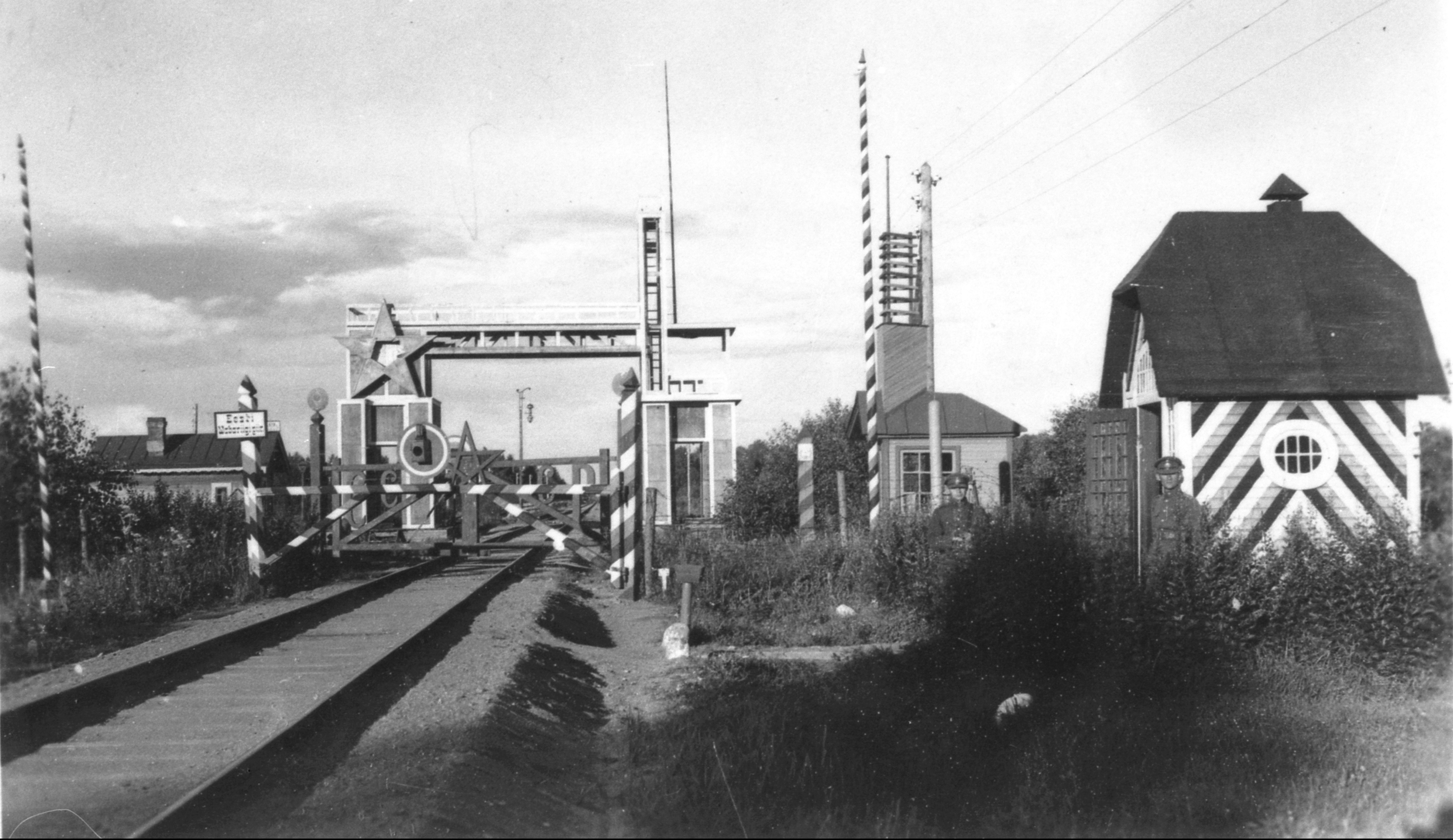
Header: The Estonian border with the Soviet Union in the 1920s [Image: herder-institut.de]
© Deep Baltic 2016. All rights reserved.
Like what Deep Baltic does? Please consider making a monthly donation – help support our writers and in-depth coverage of Estonia, Latvia and Lithuania. Find out more at our Patreon page.